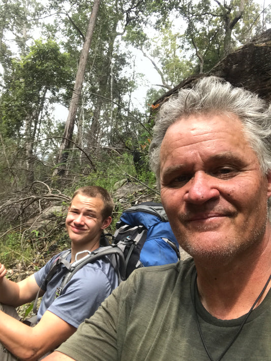
Andy Collins and his son Ben decided to locate and follow the legendary Engineer’s Track all the way down the Grose Valley. He explains what happened next.
Q: Why did you move to the Blue Mountains?
A: I moved to Blackheath in late 2015 when I took up the position as pastor at Blackheath Baptist Church. I have always hiked, especially distance hikes.
Q: What sort of walks attracted you here?
A: I always love to walk to work rather than drive, so I made sure we got a house a good distance out of town. When we lived on Shipley Road, rather than walk straight to town, I'd often hike down into the Kanimbla Valley, then come up to Blackheath via the Centennial Pass trail that leads to Porter's Pass. I love nothing more than coming upon an unmarked trail and wondering where it leads. (See later for Andy’s recommended walks in the Blue Mountains.) I rarely see anybody on the trails I've listed. Often, because of fallen trees and regrowth, few people ever use these trails.
Q: Thinking of the history of hiking in the Mountains, is Myles Dunphy an inspirational figure?
A: I loved reading Back from the Brink by Andy Macqueen and hearing about hiking in the Grose River valley. Myles Dunphy gets much of the credit. The men were legends, but I hear stories from the early 20th Century of how women had to traipse up and down Govett's Creek ridiculously overdressed, and they are equally inspiring.
Q: Have you ever come across any routes that were used by Aboriginal people?
A: The only one that I'm aware of is the access down into the Grose Valley from the top of Hat Hill Creek Falls. Allan Wells, a member of our church community, said an Aboriginal man told him that you gain access to the Grose River by heading uphill first, then making your way down the talus.
Q: Tell us about the Engineers Track in the Grose Valley.
A: I'd often been to the Blue Gum Forest and walked down to the junction of the Grose River and Govett's Creek. I always wondered if you could continue downstream, as the scenery looked incredible.
I knew that in the late 1850s, a well-made track was built right down the Grose Valley, to determine if the intended railway line across the mountains should follow that route. In the end, of course, the railway went across the ridge.

Q: It was a strange delusion, wasn’t it? I mention this in my book Tall Stories, a history of the Blueys. When you consider the very rocky landscape of the Grose, the length of the tunnel they’d have needed under the Darling Causeway, not to mention the great height disparity between the upper Grose and Hartley Vale -
A: Madness! I know from having been down there, there's no way it was ever going to work as a railway.
Q: What inspired you to try to walk the track?
A: Once I did a bit of exploring online, it seemed that it was a rarely explored area in recent times. It was the end of the long COVID lockdown of 2021. I was itching to get outside, and the rest of the state hadn't completely opened up, so I decided to stay local and do something unusual. I decided to take my teenage son Ben with me. He is extremely fit, and we went armed with a machete, just in case. We got dropped off at Perry's Lookdown, and the plan was to walk 70-80km to North Richmond Station, giving ourselves five days and four nights.
Q: How did it go?
A: It was fairly easy going for the first few kilometres, between Blue Gum Forest and nice grassy flats. However, by the Rocky Creek intersection, our progress slowed substantially. The river was flowing quite strongly, so there was no way we could rock-hop. Our progress slowed to 0.5-1 km per hour through the thickest sections. It was extremely overgrown, and there were no tracks around any of the fallen trees. We also encountered many high piles of debris.

The Engineer's Track itself was impossible to follow, there just seemed little reason as to where they built it. Sometimes we'd come across the track unexpectedly. There were small areas where there were some very well-preserved sections. Once we knew what to look for, we could more easily find it, but usually the track was buried, or had just disappeared.

Often, we'd hike uphill to try and find some clearer ground. Sometimes, we struck gold. Other times, we backtracked and found it was easier to follow the river. It was very slow going, and by the end of the fifth day, we were still about 14km from the walking track up to Faulconbridge.
At that point I pulled the personal locator beacon out of my backpack to show my son how to use it if anything should happen to me. He pressed the "TEST" button, and all seemed good. As we continued on, we noticed a chopper flying overhead. We’d seen choppers every day, so didn't think much of it. However, this one hung about, hovering overhead.
Next thing, we saw a guy descending a cable from the chopper. Once he was down, he called us over and buckled us up. Before we knew it, we were flying over the very ground we'd battled through, feeling very guilty and trying not to enjoy the view too much.
We arrived at Blackheath NPWS depot, surprised at the dozens of emergency workers who'd been called out. The guy in charge of the rescue checked our PLB. Apparently it was faulty, and had gone off when we pressed the TEST button. I had to laugh: only an hour before, I’d wondered if I'd have the strength to walk out of the valley. Now I was sitting in my living room!
Q: Any reflections on the experience?
A: I wish we'd been able to finish the entire track. It was incredibly beautiful, yet very rugged country. We both felt very privileged to have visited the section we did walk, really tapping into that pioneer spirit that must've been needed to build the track.
Q: Will you try again?
A: I was speaking with Ben the other day. We've definitely both got a case of hiker's amnesia, forgetting a lot of the difficult experiences, and only remembering how awesome it was. We're actually planning to walk it again. We'll wait until we're well and truly out of this horrible La Nina weather event. It will be a much easier walk, even a pleasant occasional rock-hop, if we can get closer to the river. We'll give ourselves a full week next time.
Q: Any thoughts on preserving the track - is it worth bringing it back to life?
A: I read that a group called the Engineers Track Heritage Infrastructure Committee had plans in the early 2000s to restore the entire track. Having walked many long-distance tracks around the world, I can say the Grose River Valley is absolutely world class. It is 100 per cent worth bringing back to life. But it would need not only to be restored - a commitment would need to be made to provide regular upgrading of the track.
We haven’t been able to find any current trace of the Engineers Track Heritage Infrastructure Committee, but would be glad to hear from anyone about reopening this wonderful track. As Andy says, the potential is enormous – even if not for a railway.

Recommended walks in the Blue Mountains, from Andy Collins.
I now live in Katoomba. My first recommendation is a loop from my house that follows the Prince Henry Cliff Walk to Sublime Point, down the Copeland Pass Trail, then following the Lindeman Pass Trail that goes behind Gordon Falls, coming up Federal Pass past Linda and Lila Falls.
I love riding a mountain bike along the Faulconbridge Ridge trail, then hiking the Grose River Walking Trail that drops down to this amazing, large swimming hole. A very steep trail indeed!
I particularly love trails to the lesser-known passes, such as Carlon Head on Narrow Neck and Copeland Pass in Leura.
When I lived in Blackheath, a favourite walk was from my house in Cross St, dropping onto the Braeside Walk, then following the powerlines trail that comes out at the camping ground near Evan's Lookout. I then hike the Grand Canyon walking trail, detouring up the old track to Point Pilcher Rd, then dropping down the fire trail to rejoin the Grand Canyon, with a detour to the Bottomless Pool. I then take various lesser known tracks and trails back to Cross St.
Honourable mentions would be the amazing Jungle Circuit which was accessible from the trail to the base of Bridal Veil Falls (currently closed); Bruce's Walk between Medlow Bath and Leura; anything around the Wild Dog Mountains; taking my kids down the easily-accessible Hat Hill Canyon; and the wonderful lesser-known trail network northeast of Blackheath, accessible from Mount Hay Road, such as Arethusa Canyon, Fortress Creek, the Dr Dark's Cave area, Lockleys Pylon and the wonderful descent to the Grose River via Du Faur's Head.
After my recent move to Katoomba, I'm also enjoying exploring new lesser-known areas such as the Devil's Hole, and the western side of Narrow Neck and Radiata Plateau. I highly recommend the historic trails accessible via Mount York Road, such as Berghoffer's Pass, Lockyer's, Lawson Long Alley and the descent from Mount York to Hartley Vale. The list is endless ...